All About Geospatial Information Scientists and Technologists
Job Description: Research or develop geospatial technologies. May produce databases, perform applications programming, or coordinate projects. May specialize in areas such as agriculture, mining, health care, retail trade, urban planning, or military intelligence.
Life As a Geospatial Information Scientist or Technologist
- Design, program, or model Geographic Information Systems (GIS) applications or procedures.
- Perform computer programming, data analysis, or software development for Geographic Information Systems (GIS) applications, including the maintenance of existing systems or research and development for future enhancements.
- Create, analyze, report, convert, or transfer data, using specialized applications program software.
- Assist users in formulating Geographic Information Systems (GIS) requirements or understanding the implications of alternatives.
- Create visual representations of geospatial data, using complex procedures such as analytical modeling, three-dimensional renderings, or plot creation.
- Read current literature, talk with colleagues, continue education, or participate in professional organizations or conferences to keep abreast of developments in Geographic Information Systems (GIS) technology, equipment, or systems.
Things a Geospatial Information Scientist or Technologist Should Know How to Do
Geospatial Information Scientists and Technologists state the following job skills are important in their day-to-day work.
Reading Comprehension: Understanding written sentences and paragraphs in work related documents.
Science: Using scientific rules and methods to solve problems.
Active Listening: Giving full attention to what other people are saying, taking time to understand the points being made, asking questions as appropriate, and not interrupting at inappropriate times.
Writing: Communicating effectively in writing as appropriate for the needs of the audience.
Speaking: Talking to others to convey information effectively.
Critical Thinking: Using logic and reasoning to identify the strengths and weaknesses of alternative solutions, conclusions or approaches to problems.
Types of Geospatial Information Scientist or Technologist Jobs
- Geographic Information Systems Specialist (GIS Specialist)
- Geographic Information Systems Administrator (GIS Administrator)
- Geographic Information Systems Analyst (GIS Analyst)
- Geographic Information Systems Coordinator (GIS Coordinator)
- Geographic Information Systems Physical Scientist (GIS Physical Scientist)
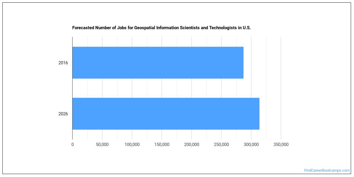
Is There Going to be Demand for Geospatial Information Scientists and Technologists?
In the United States, there were 287,200 jobs for Geospatial Information Scientist or Technologist in 2016. New jobs are being produced at a rate of 9.3% which is above the national average. The Bureau of Labor Statistics predicts 26,600 new jobs for Geospatial Information Scientist or Technologist by 2026. Due to new job openings and attrition, there will be an average of 22,400 job openings in this field each year.
The states with the most job growth for Geospatial Information Scientist or Technologist are Washington, Utah, and Nevada. Watch out if you plan on working in Alaska, Maryland, or Mississippi. These states have the worst job growth for this type of profession.
Do Geospatial Information Scientists and Technologists Make A Lot Of Money?
The average yearly salary of a Geospatial Information Scientist or Technologist ranges between $47,350 and $144,820.
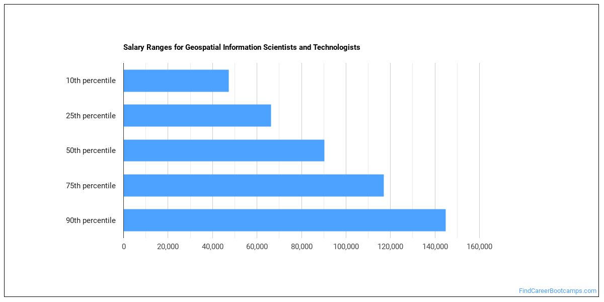
Geospatial Information Scientists and Technologists who work in District of Columbia, Maryland, or New Hampshire, make the highest salaries.
How much do Geospatial Information Scientists and Technologists make in each U.S. state?
| State | Annual Mean Salary |
|---|---|
| Alabama | $87,060 |
| Alaska | $98,830 |
| Arizona | $85,010 |
| Arkansas | $73,670 |
| California | $103,270 |
| Colorado | $102,470 |
| Connecticut | $100,340 |
| District of Columbia | $117,540 |
| Florida | $78,900 |
| Georgia | $90,140 |
| Hawaii | $89,960 |
| Idaho | $80,610 |
| Indiana | $79,310 |
| Iowa | $78,810 |
| Kansas | $79,300 |
| Kentucky | $79,420 |
| Louisiana | $66,600 |
| Maine | $79,790 |
| Maryland | $113,330 |
| Massachusetts | $92,110 |
| Michigan | $76,400 |
| Minnesota | $81,650 |
| Mississippi | $81,280 |
| Missouri | $82,610 |
| Montana | $68,430 |
| Nebraska | $86,230 |
| Nevada | $72,610 |
| New Hampshire | $112,440 |
| New Jersey | $99,210 |
| New Mexico | $79,540 |
| New York | $90,750 |
| North Carolina | $88,650 |
| North Dakota | $70,730 |
| Ohio | $82,440 |
| Oklahoma | $78,490 |
| Oregon | $79,610 |
| Pennsylvania | $87,040 |
| Rhode Island | $81,290 |
| South Carolina | $92,100 |
| South Dakota | $81,250 |
| Tennessee | $74,000 |
| Texas | $90,290 |
| Utah | $76,890 |
| Vermont | $72,220 |
| Virginia | $105,270 |
| Washington | $91,620 |
| West Virginia | $83,660 |
| Wisconsin | $74,600 |
| Wyoming | $75,780 |
What Tools & Technology do Geospatial Information Scientists and Technologists Use?
Below is a list of the types of tools and technologies that Geospatial Information Scientists and Technologists may use on a daily basis:
- Microsoft Excel
- Microsoft Word
- Microsoft Office
- Hypertext markup language HTML
- Microsoft PowerPoint
- Web browser software
- Python
- Microsoft Access
- Data entry software
- Autodesk AutoCAD
- Microsoft SharePoint
- Adobe Systems Adobe Photoshop
- Structured query language SQL
- The MathWorks MATLAB
- SAS
- Microsoft Visual Basic
- Adobe Systems Adobe Illustrator
- Extensible markup language XML
- Microsoft SQL Server
- UNIX
Becoming a Geospatial Information Scientist or Technologist
What education or degrees do I need to become a Geospatial Information Scientist or Technologist?

How Long Does it Take to Become a Geospatial Information Scientist or Technologist?
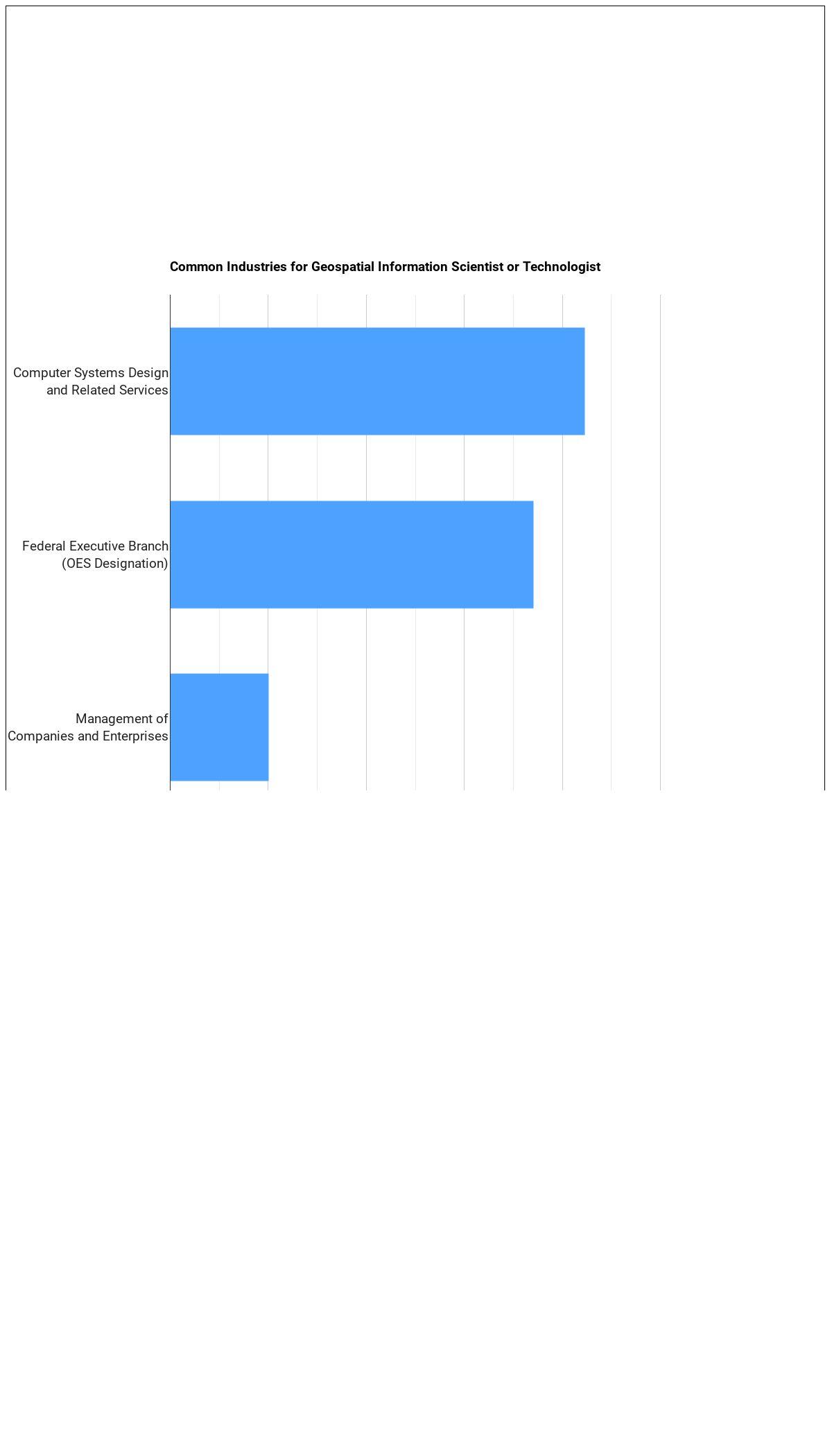
Where Geospatial Information Scientists and Technologists Work
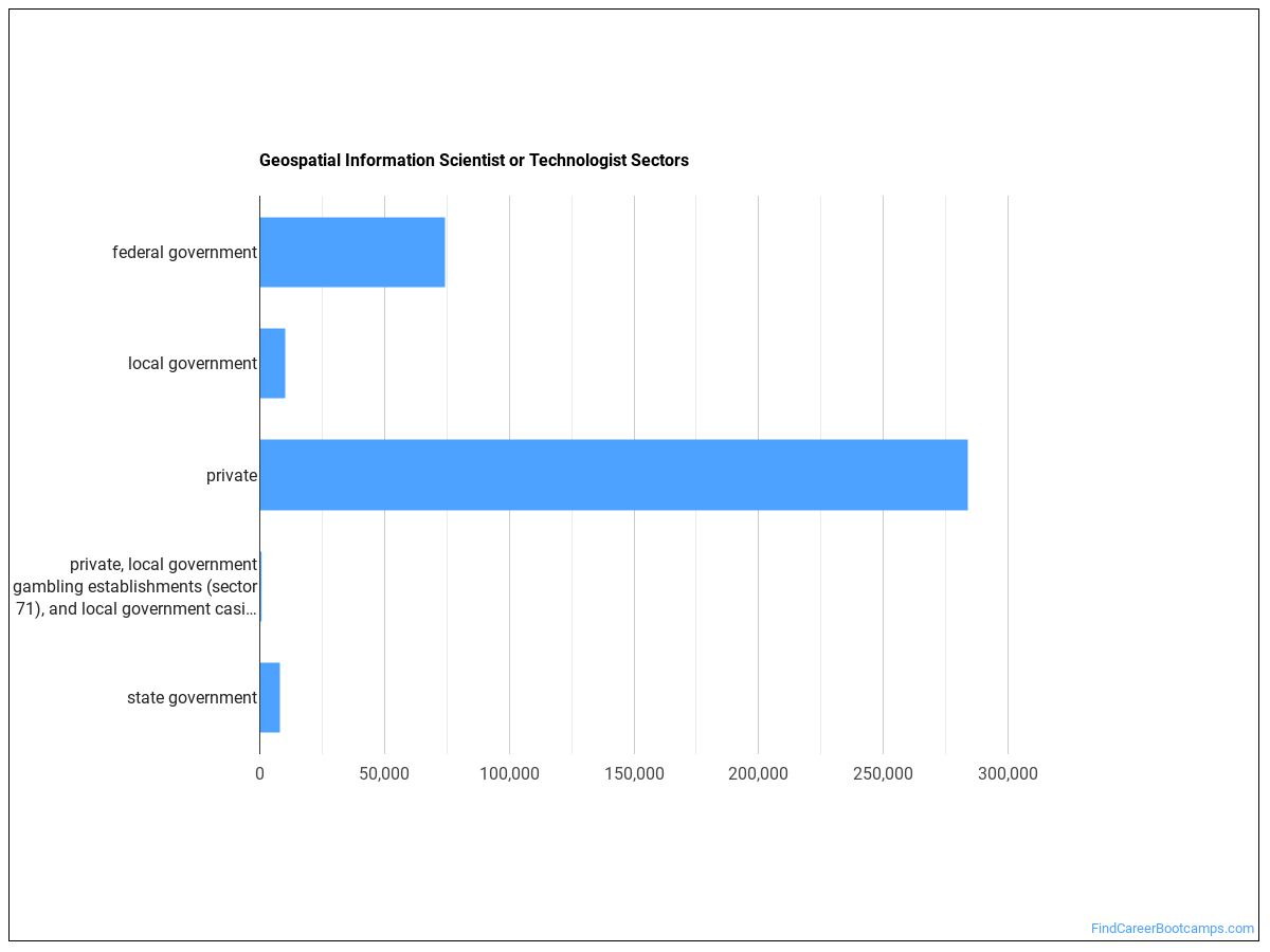
The table below shows the approximate number of Geospatial Information Scientists and Technologists employed by various industries.
Other Jobs You May be Interested In
Those interested in being a Geospatial Information Scientist or Technologist may also be interested in:
Career changers with experience as a Geospatial Information Scientist or Technologist sometimes find work in one of the following fields:
References:
Image Credit: Negative Space via CC0 License
More about our data sources and methodologies.
Find Career Bootcamps provides higher-education, college and university, degree, program, career, salary, and other helpful information to students, faculty, institutions, and other internet audiences. Presented information and data are subject to change. Inclusion on this website does not imply or represent a direct relationship with the company, school, or brand. Information, though believed correct at time of publication, may not be correct, and no warranty is provided. Contact the schools to verify any information before relying on it. Financial aid may be available for those who qualify. The displayed options may include sponsored or recommended results, not necessarily based on your preferences.
© Find Career Bootcamps – All Rights Reserved.