What Does it Take to Be a Geographic Information Systems Technician?
Geographic Information Systems Technician Job Description Assist scientists, technologists, or related professionals in building, maintaining, modifying, or using geographic information systems (GIS) databases. May also perform some custom application development or provide user support.
A Day in the Life of a Geographic Information Systems Technician
- Perform geospatial data building, modeling, or analysis, using advanced spatial analysis, data manipulation, or cartography software.
- Maintain or modify existing Geographic Information Systems (GIS) databases.
- Participate in projects that map changes in carbon emissions levels across different geographic locations, using Geographic Information Systems (GIS) data.
- Select cartographic elements needed for effective presentation of information.
- Design or prepare graphic representations of Geographic Information Systems (GIS) data, using GIS hardware or software applications.
- Interpret aerial or ortho photographs.
Geographic Information Systems Technician Required Skills
Below is a list of the skills most Geographic Information Systems Technicians say are important on the job.
Critical Thinking: Using logic and reasoning to identify the strengths and weaknesses of alternative solutions, conclusions or approaches to problems.
Reading Comprehension: Understanding written sentences and paragraphs in work related documents.
Speaking: Talking to others to convey information effectively.
Complex Problem Solving: Identifying complex problems and reviewing related information to develop and evaluate options and implement solutions.
Active Learning: Understanding the implications of new information for both current and future problem-solving and decision-making.
Judgment and Decision Making: Considering the relative costs and benefits of potential actions to choose the most appropriate one.
Related Job Titles for this Occupation:
- Geospatial Specialist
- Business Analyst
- Geographical Information System Specialist (GIS Specialist)
- Cartographic Technician
- Geographic Information Systems Specialist (GIS Specialist)
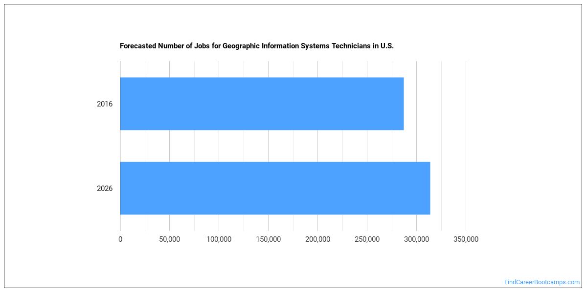
Job Outlook for Geographic Information Systems Technicians
There were about 287,200 jobs for Geographic Information Systems Technician in 2016 (in the United States). New jobs are being produced at a rate of 9.3% which is above the national average. The Bureau of Labor Statistics predicts 26,600 new jobs for Geographic Information Systems Technician by 2026. There will be an estimated 22,400 positions for Geographic Information Systems Technician per year.
The states with the most job growth for Geographic Information Systems Technician are Washington, Utah, and Nevada. Watch out if you plan on working in Alaska, Maryland, or Mississippi. These states have the worst job growth for this type of profession.
How Much Does a Geographic Information Systems Technician Make?
Geographic Information Systems Technicians make between $47,350 and $144,820 a year.
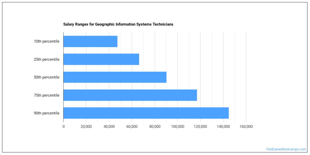
Geographic Information Systems Technicians who work in District of Columbia, Maryland, or New Hampshire, make the highest salaries.
How much do Geographic Information Systems Technicians make in different U.S. states?
| State | Annual Mean Salary |
|---|---|
| Alabama | $87,060 |
| Alaska | $98,830 |
| Arizona | $85,010 |
| Arkansas | $73,670 |
| California | $103,270 |
| Colorado | $102,470 |
| Connecticut | $100,340 |
| District of Columbia | $117,540 |
| Florida | $78,900 |
| Georgia | $90,140 |
| Hawaii | $89,960 |
| Idaho | $80,610 |
| Indiana | $79,310 |
| Iowa | $78,810 |
| Kansas | $79,300 |
| Kentucky | $79,420 |
| Louisiana | $66,600 |
| Maine | $79,790 |
| Maryland | $113,330 |
| Massachusetts | $92,110 |
| Michigan | $76,400 |
| Minnesota | $81,650 |
| Mississippi | $81,280 |
| Missouri | $82,610 |
| Montana | $68,430 |
| Nebraska | $86,230 |
| Nevada | $72,610 |
| New Hampshire | $112,440 |
| New Jersey | $99,210 |
| New Mexico | $79,540 |
| New York | $90,750 |
| North Carolina | $88,650 |
| North Dakota | $70,730 |
| Ohio | $82,440 |
| Oklahoma | $78,490 |
| Oregon | $79,610 |
| Pennsylvania | $87,040 |
| Rhode Island | $81,290 |
| South Carolina | $92,100 |
| South Dakota | $81,250 |
| Tennessee | $74,000 |
| Texas | $90,290 |
| Utah | $76,890 |
| Vermont | $72,220 |
| Virginia | $105,270 |
| Washington | $91,620 |
| West Virginia | $83,660 |
| Wisconsin | $74,600 |
| Wyoming | $75,780 |
What Tools & Technology do Geographic Information Systems Technicians Use?
Although they’re not necessarily needed for all jobs, the following technologies are used by many Geographic Information Systems Technicians:
- Microsoft Excel
- Microsoft Word
- Microsoft Office
- Hypertext markup language HTML
- JavaScript
- Microsoft PowerPoint
- Web browser software
- Python
- Microsoft Access
- Email software
- SAP
- Autodesk AutoCAD
- Adobe Systems Adobe Acrobat
- Microsoft Visio
- Adobe Systems Adobe Photoshop
- Structured query language SQL
- Adobe Systems Adobe Illustrator
- Extensible markup language XML
- Microsoft SQL Server
- Geographic information system GIS software
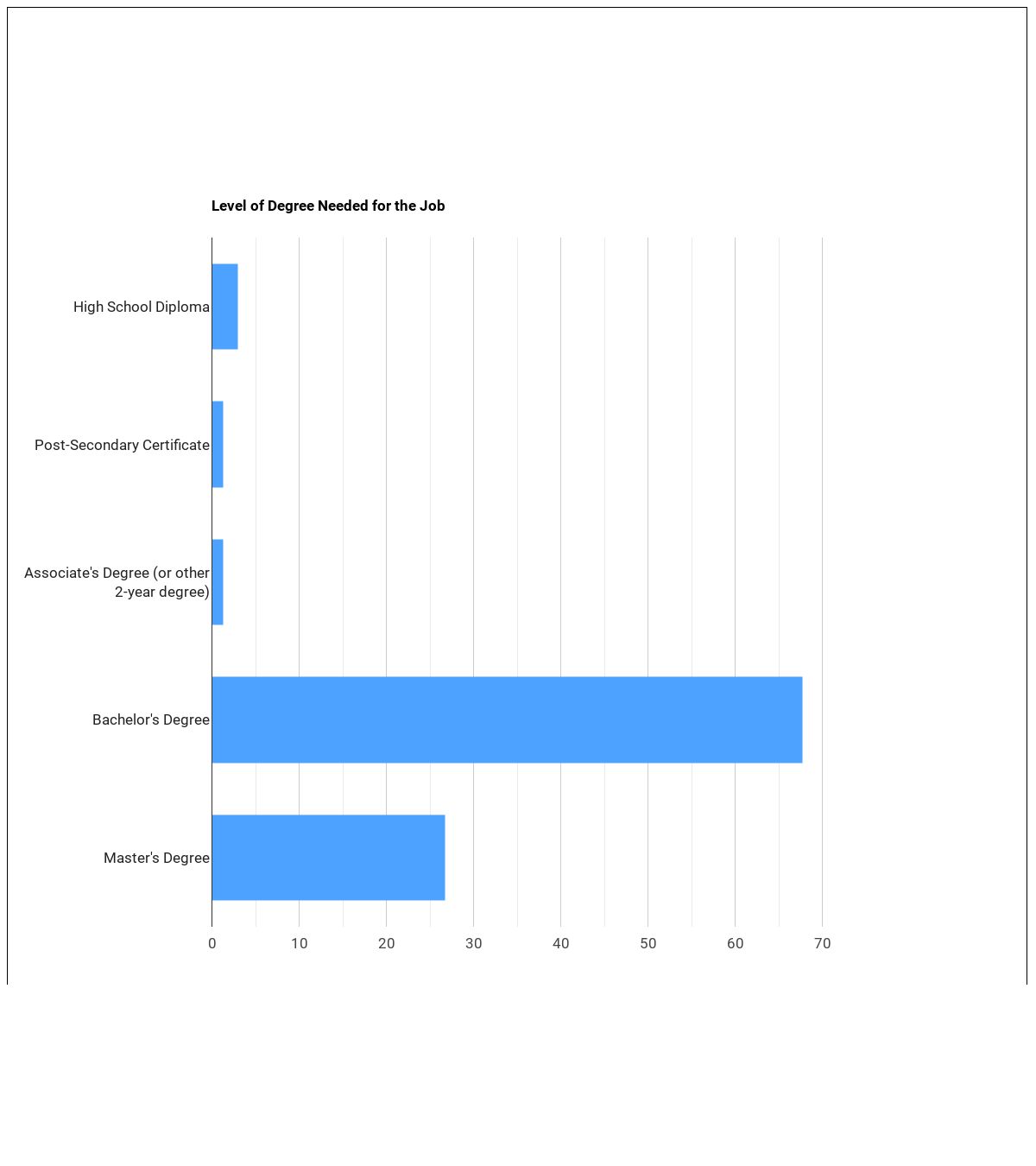
Becoming a Geographic Information Systems Technician
Individuals working as a Geographic Information Systems Technician have obtained the following education levels:
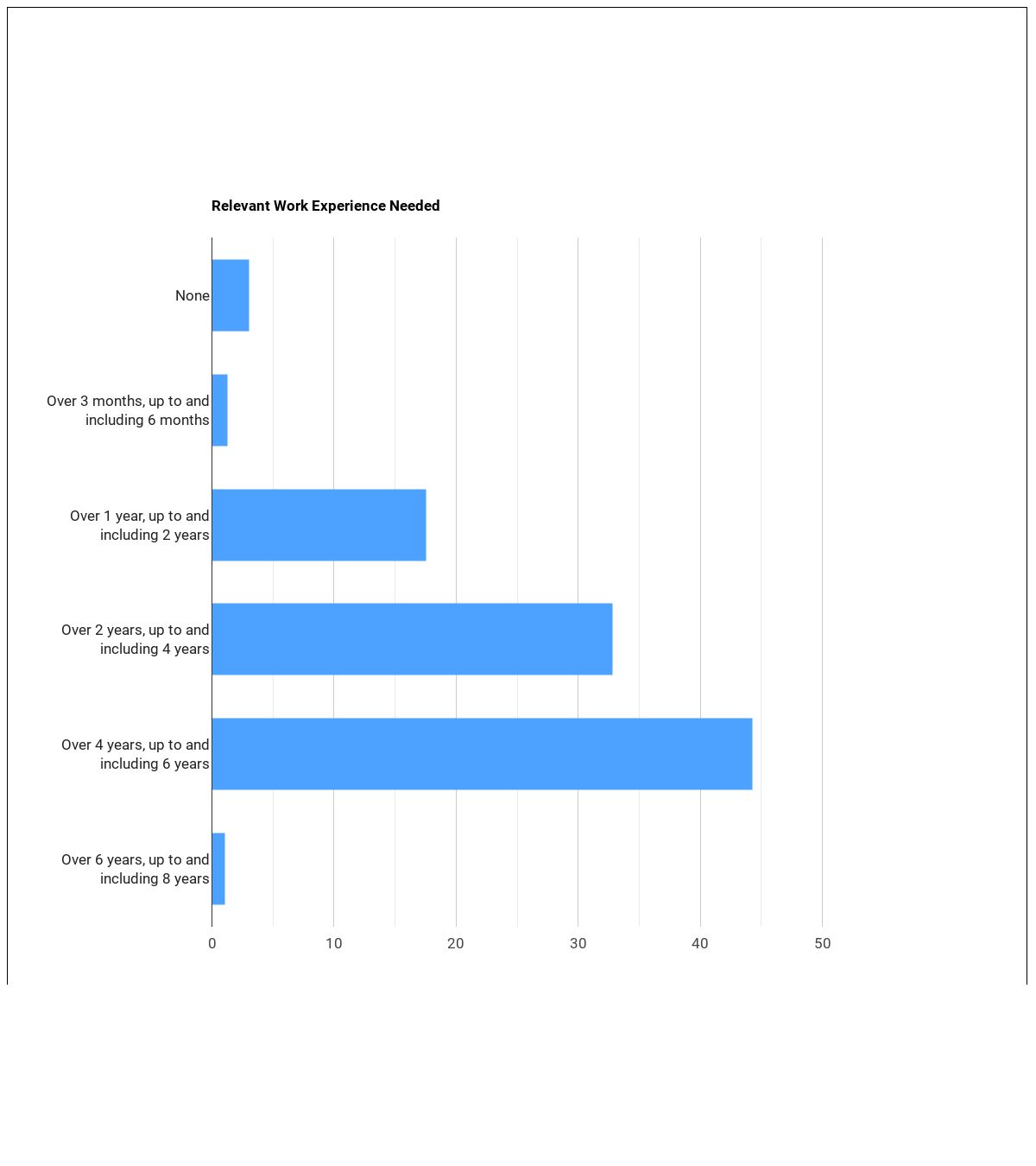
What work experience do I need to become a Geographic Information Systems Technician?
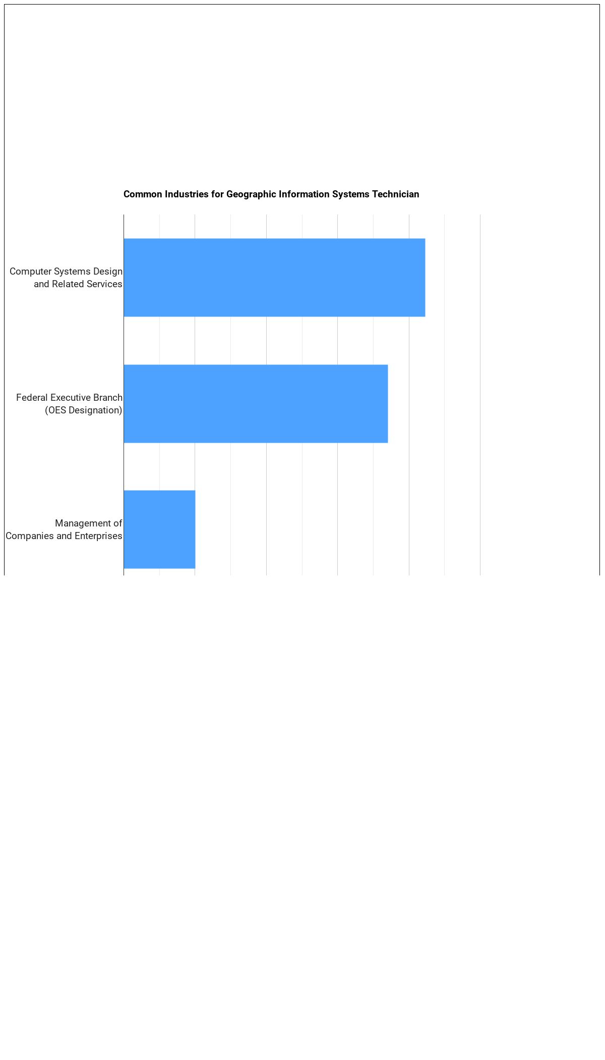
Where Geographic Information Systems Technicians Work
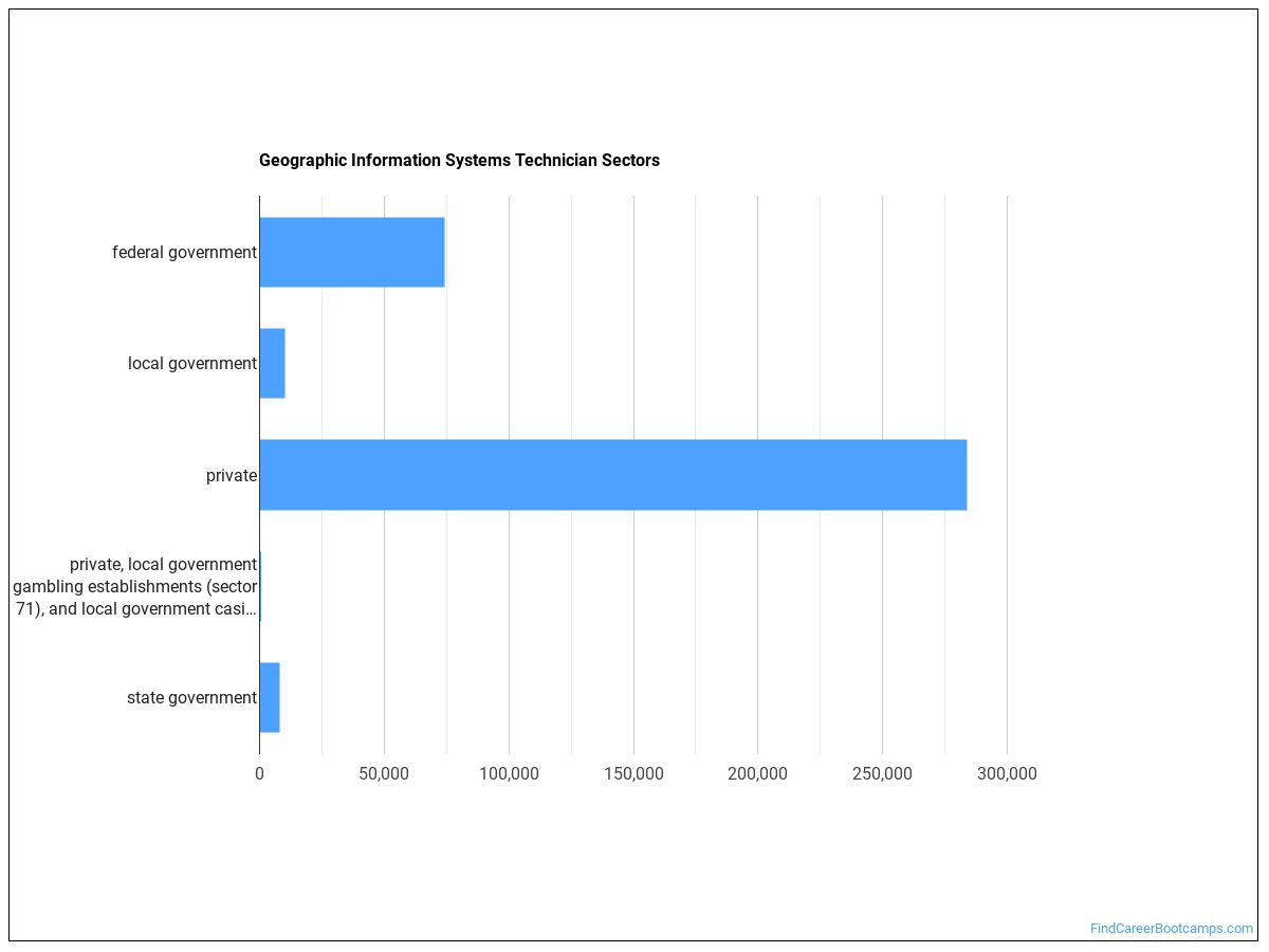
The table below shows some of the most common industries where those employed in this career field work.
Other Jobs You May be Interested In
Those interested in being a Geographic Information Systems Technician may also be interested in:
Are you already one of the many Geographic Information Systems Technician in the United States? If you’re thinking about changing careers, these fields are worth exploring:
References:
Image Credit: The Opte Project via Creative Commons Attribution 2.5 Generic
More about our data sources and methodologies.
Find Career Bootcamps provides higher-education, college and university, degree, program, career, salary, and other helpful information to students, faculty, institutions, and other internet audiences. Presented information and data are subject to change. Inclusion on this website does not imply or represent a direct relationship with the company, school, or brand. Information, though believed correct at time of publication, may not be correct, and no warranty is provided. Contact the schools to verify any information before relying on it. Financial aid may be available for those who qualify. The displayed options may include sponsored or recommended results, not necessarily based on your preferences.
© Find Career Bootcamps – All Rights Reserved.